 On Saturday, November 12th, we hosted a hike on our lovely 600-acre Webb Conservation Easement near Panthertown Valley in Jackson County. This beautiful property is bounded on the north side by Cedar Creek, a high quality tributary flowing into Webb Lake, which provides habitat for native brook trout. All water on the property eventually drains into the West Fork of the Tuckaseegee River, and on into the Little Tennessee River.
On the day of the hike, we were met at the property by members of the Webb family who own the property – Billy, Jimmy, and Jean Webb, as well as Julia Gaskin. The family introduced themselves briefly, and Billy, Jimmy, and Julia accompanied us on the hike.
The route followed about 3 miles of well-established trails in a loop around nearly half of the 600-acre property. The trails led us through primarily acidic cove forest, under rhododendron tunnels and through laurel archways. The group stopped for lunch on “Laura’s Rock,” a granite rock outcrop at nearly 4000’ in elevation, with scenic views to the south and west. Even with some haze from the many wildfires burning in the area, we could see as far as Yellow Mountain, about 5.3 miles away as the crow flies.
When we returned to the family cabin where we began the hike, other members of the family had joined Jean and were waiting for us with crisp fall cider and cookies following our adventure.
 While we ate our refreshments, just as during the hike, we all had a chance to talk to the family about their memories and experiences on the property, and their knowledge of some of the flora and fauna there.
This stunning property continues to be a staff favorite. Lisa, our Finance Director, said “I want to come on this hike every time we do it from now on! Every step of the way has been the most beautiful scenery I’ve ever seen.”
We are so thankful to the Webb family for allowing us to do a hike on their property, and we look forward to the next time!


 At the end of December we purchased a 7-acre inholding surrounded by protected land just below Carvers Gap in the Highlands of Roan. The tract adjoins an SAHC preserve and Pisgah National Forest. Although small in acreage, it was a high conservation priority because of its location and visibility from the Appalachian Trail at Round Bald and Jane Bald.
 “Surrounded by permanently protected land, these seven acres were essentially an ‘inholding’ — the type of property people seek out for private residential development,” continued Pugliese. “This tract was the closest unprotected land to Carvers Gap, the public access to the Highlands of Roan and the Appalachian Trail. In buying this property, we carry forward our organization’s roots of protecting the Roan and preserving views from the Appalachian Trail.”
 Dominated by northern hardwood forest, the tract rises to an elevation of 5,220 ft. and has 435 ft. of road frontage on Highway 261, the route to the Carvers Gap parking area. The property lies within the Audubon Society’s Roan Mountain Important Bird Area and the state-designated Roan Massif Natural Area. Two tributaries of Johns Camp Branch flow through the parcel; Johns Camp Branch empties into Fall Creek, which is classified as High Quality Waters and Trout Waters.
 For college students during the exam season, late November and early December can be riddled with stress, anxiety and wary nerves. Many students find that breaking from long hours in the library to spend time outside, for a breath of fresh air and a pause from the stress, can actually boost effectiveness when they do return to their books.
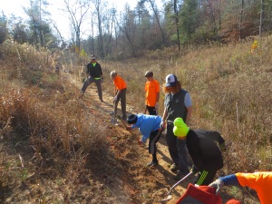
 Golden-winged Warblers (GWWA) are a neo-tropical, migratory songbirds that overwinter in Central and South America. In the summer months, these birds return to the highest peaks of the Appalachian Mountains; they particularly enjoy our land at Grassy Ridge. GWWA prefer young shrubby habitat or regenerating forest edges. They also move quickly to mature forest after fledging, so the high elevation open areas of this property – surrounded by hundreds of acres of conserved forest – provide perfect habitat. GWWA have suffered an extreme decline in population over the past half a century. They have one of the smallest populations amongst species not on the endangered species list. We strive to preserve habitat for this and other species in our landscape.
 Our ten generous volunteers worked with weed eaters and clippers to knock back overgrown black berries bushes that surrounded our Bird House cabin, and then collect and pile the cut branches into three large brush piles. Such brush piles provide optimal areas for GWWA to breed and forage. The work was also effective in distracting the volunteers from stressful circumstances.
 Jay spent time around the fire with the group after the work was done, further explaining the importance of conservation, thanking the group for their hard work, and wishing them luck on their impending exams.
 Blue Hill Essentials
 A cold morning brightened up on November 18th just in time to indulge a large group of AmeriCorps members on a tour of our Community Farm. Chris Link, SAHC’s Community Farm Manager, and Travis Bordley, our Roan Volunteer Outreach Associate, hosted 26 AmeriCorps members from Project POWER, which stands for “Putting Opportunity Within Everyone’s Reach.”
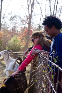 “The current group of AmeriCorps members with Project Power is a really special team,” said Travis. “They all are incredibly positive individuals with a passion for what they do. We think our resources at the farm can help to serve them and bolster our relationship with youth in the community.”
 Seventeen of the 26 visitors signed up with Travis after the tour in hopes to return to the farm with their children, and four members were also interested in doing environmental education programming on other SAHC properties. The beautiful weather really seemed to compliment a great relationship that is growing between SAHC and Project POWER!
 The phrase, “Mind over matter”, was put to the test when the UNC-Asheville Mindfulness club volunteered for a day with SAHC. Travis Bordley, our new Americorps Roan Outreach Associate, hosted 4 members of club and volunteers Saylor Fox and Bettye Boone for a trash clean-up day on a conservation property in the Highlands of Roan. The tract is located in just below Carver’s Gap on the North Carolina side of the ridge, and people pulling off to the side of Highway 261 have thrown empty bottles, trash bags, and tires onto it. Travis and his brave volunteer group came in to remedy the situation.
 After lunch the crew decided to carry on with the days itinerary and go for a hike up Round Bald. Starting from about 1,000 below the summit, the mountain was consumed in a cloud of blowing ice. The view looked like the inside of a ping pong ball. The group struggled to maintain footing against the wind, fueled by the wonder of the Roan. Everyone was amazed by the arctic conditions that existed only at this elevation. At the top the group took its time rolling in the snow and taking pictures of the ice caked landscape. The Mindfulness Club, Saylor, Bettye, and Travis all took turns doing solo-hikes down from the summit.

 This month, twelve 7th grade boys from the French Broad River Academy (FBRA) volunteered at our Community Farm. We are grateful for assistance from these positive, hard-working students! Service learning is a vital piece of the FBRA curriculum, and they partner with us several times a year to help out with various projects at the Community Farm.
 Once the digging and grading were mostly done, the boys began to take turns setting logs in place along the wall, and using a post-driver and hammer to drive in rebar to hold the logs. Others helped back-fill the top of the wall with the dirt they had removed earlier.


 This month we protected 32 acres of farmland in the shadow of Crabtree Bald in Haywood County. Located along Rush Fork Creek and adjacent to NC Scenic Byway 209, the farm contains prime agricultural soils and has been in the same family since the late 1700s.
 rotection of the farm also adds to a significant protected landscape within the Newfound Mountains and preserves pastoral views along Rush Fork Road (also known as The Appalachian Medley), a rural NC scenic highway. The property adjoins a 625-acre NC Farmland Preservation Trust Fund Easement property, held by the NC Department of Agriculture. The vast connectivity of all farmland and forested land in the general vicinity of the property is important for agricultural viability of the region as well as plant and animal diversity.

