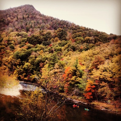
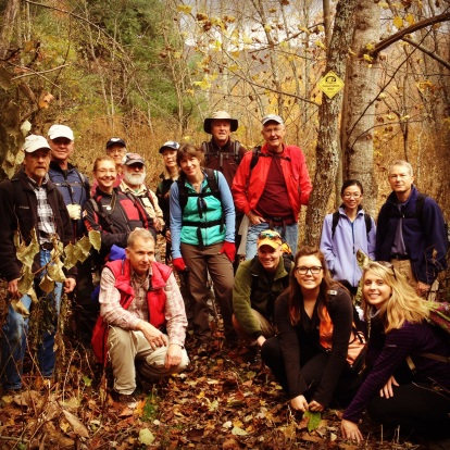
Although we are in the midst of an arctic freeze in the Southern Appalachian Mountains, we’re eagerly looking forward to the slate of outdoor adventures our outreach team has planned for this year. To whet your appetite, here’s a narrative from one of our 2013 fall hikes – a trek into the 95-acre Lost Cove tract that SAHC purchased in 2012, led by our AmeriCorps PR & Outreach associate Anna Zanetti:
“Lost Cove, once a self-sustaining community nestled on the border between North Carolina and Tennessee, has become a mere ghost town with the occasional company of a destination hiker.
In late November I led 22 people on a hike to the old settlement where only abandoned and crippled buildings now exist. The group hiked up to Flat Top Mountain where we peeked over the edge looking down on the Nolichucky Gorge catching a glimpse of the Lost Cove Property. During the 1940s, from this point, you would have been able to see white buildings consisting of homes, the schoolhouse and the church, but all we saw was overgrowth amongst the color changing leaves. We headed west and began to descend two miles along the old soil bed road until we came to an intersection in the trail. This intersection marks the beginning of the Lost Cove settlement and to the left marks SAHC’s property.
We walked quietly under the dark clouds that came rushing in, covering the sun. Searching around the group examined the free standing stone chimneys and the decaying structures. Every few feet we would see old deteriorating cans, rusty car parts and we even found a wood-burning stove. We all navigated around on and off trail as if we were investigating an ancient civilization. Everyone was dispersed when a hiker called out, “Come up here, I found their cemetery.” We all rushed together to the top of a hill off of the trail to find a small gated graveyard with tombstones and some flowers. We knelt down reading the literature engraved in the stones — some had poems or just the family name, in places the letters were a little off and the p’s and d’s were backwards. On top of the hill we had a brief snack, but we were too engaged to turn around at that point. As a group we decided to push forward and hike down to the Nolichucky Gorge to see the train tracks and where the train platform once existed.
The group hiked about 1.5 miles descending through bolder fields with moss and lichen in every nook and cranny. It was like a sea of rocks flowing and rising within the tress. This section of the trail is by far my favorite because of its natural beauty. We reached the edge of our property looking upon the Nolichucky River and the train tracks nestled between the surrounding mountains. We all dispersed around the edge of the property to explore. Then we reconvened around an abandoned campsite, all quiet and ready to eat our lunch. As I was getting settled the ground began to shake and we all stood up to see a train coming around the bend along the river. The graffiti covered railroad carts rushed by caring black coal and other cargo.
After the train was gone a fellow hiker said aloud, “These people had to hike 1.5 miles down here for goods and then proceeded to hike back up the steep and rocky trail with extra weight on their backs.” This reminded everyone that Appalachian folk were and still are resilient people who don’t back down from a challenge. We packed up our belongings and I handed out trash bags and gloves to anyone willing to pickup and pack out the garbage from the abandoned campsite. Buddy Tignor, President of SAHC’s Board of Trustees, single-handedly packed out around 30 pounds of empty propane cans and debris.
The train was long gone and we were finishing packing up when it began to rain. We didn’t think much about it until the rain became worse, eventually turning into hail. We all looked at each other and understood that it was time to begin the trek up and out the gorge. The hail stinging our bare skin was not our only concern — the slippery unsure footing made me nervous. A total of 45 minutes later and 1.5 miles up the steep terrain the rain and hail had stopped, giving us the opportunity to catch our breath.
The hike back was severely strenuous especially with the added weight from the trash we had picked up below. That morning we began the hike at 10:00 am and did not make it back to Flat Top Mountain till 5:00 pm. To say the least we were all exhausted, but we had formed an undeniable bond and gained a deeper appreciation for all the settlers who chose to call the Lost Cove their home.”
The next Lost Cove Hike will be held on April 26, 2014. Due to the increased popularity of this guided hike, we will open registration to SAHC members from March 1st through the 31st, followed by open registration for the general public after March 31. Please email Anna@appalachian.org for more info or to register.


I thought you were about to talk about Cades Cove in the Smoky Mountains but wow the Lost Cove looks awesome! You should check out Cades Cove its one of my favorite and is legendary for brown bear sightings! Here’s what im talking about http://smokymountainstraveltips.blogspot.com/2013/12/cades-cove.html